Weather Channel: when first accumulating snow arrives in 2026
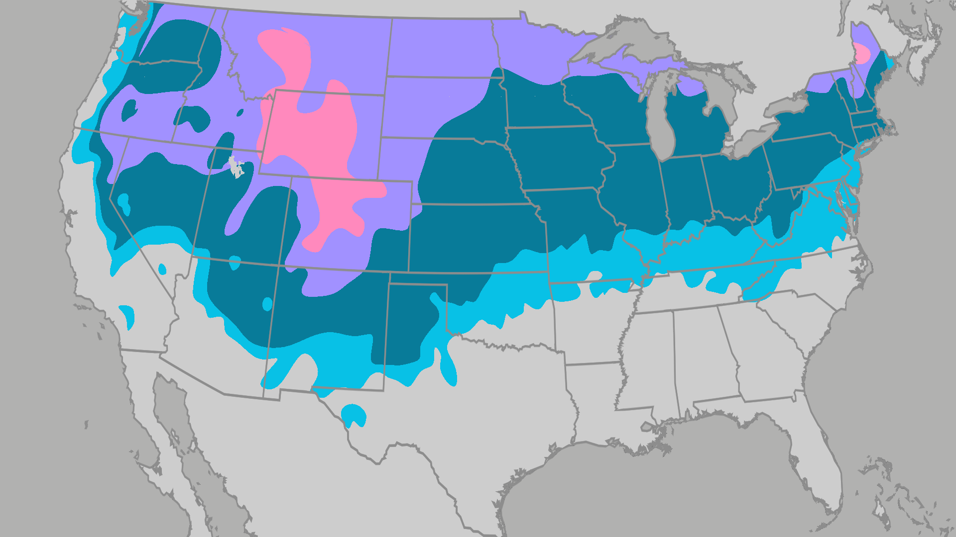
According to The Weather Channel, the first accumulating snowfall typically arrives in October across the northern tier and Mountain West, while many areas wait until November or December. Measurable snow means 0.1 inches or more—not flurries that melt on contact. A strong El Niño may push first snow later than average across much of the North.
Key Takeaways
- Accumulating snow means 0.1 inches or more, based on 1991–2020 National Weather Service averages.
- Northern Michigan to the western Dakotas and higher Rockies often see first flakes in October; I-95 cities often wait until December.
- The Weather Channel says El Niño may delay first snow in the Northeast and Midwest, while parts of the West and South could see better snow chances.
- Wisconsin’s first snow usually falls in October, though FOX6 notes El Niño could delay onset and cut totals.
For winter forecast and alert roundups, see our Streaming & TV Alerts hub.
When does the average first accumulating snow arrive?
A Weather Channel guide maps the month of average first accumulating snowfall using NOAA’s 30-year normals. Any season can run early or late.
In the Midwest, northern Michigan to the western Dakotas often sees accumulating snow in October. November typically brings snow to much of the Ohio Valley, the rest of the Great Lakes, the mid-Mississippi Valley, and the Central Plains. Parts of southeast Kansas, southern Missouri, and the Lower Ohio Valley often wait until December.
In the Northeast and mid-Atlantic, October usually brings first snow to northern New England mountains and the Adirondacks. Most of the interior Northeast joins in November, while the I-95 corridor from New York City to Virginia typically waits until December.
Out West, September is typical for higher elevations from western Montana into the Colorado Rockies. October often marks first flakes at lower elevations in Montana, Wyoming, the Wasatch, Colorado foothills and valleys, and northern New Mexico mountains. Seattle and Portland usually wait until late December.
How could El Niño change the first snow timeline?
The Weather Channel reports a strong El Niño should shape this winter’s first snowfalls. Classic El Niño winters tend to run wetter across much of the southern U.S., from parts of California to the Carolinas, while much of the northern U.S. runs warmer—and often less snowy.
This season, the Weather Channel expects first accumulating snow much later than average in the Northeast and mid-Atlantic, with thin, inconsistent early snow. The Midwest faces poor snowfall prospects and a later-than-normal first accumulation.
Colorado and Utah should still see a typical October or November start. California and Nevada could see an earlier-than-average first snowfall. The South does not see snow every year, but a wetter pattern raises the January–February chance.
What do regional maps and local forecasts say for 2026?
Mental Floss, citing a Farmers’ Almanac map, says northern mountain sections of Washington, Montana, Idaho, and Wyoming are among the earliest for snow. Northern Rockies and Plains plus parts of New England can expect October snow based on prior years, with a second wave possible across northern New England, the Dakotas, Minnesota, and northwestern Wisconsin.
November may expand coverage to Colorado, Utah, the Great Lakes, Pennsylvania, the rest of New York, southern New England, and higher Appalachian elevations. Mid-America may join around Thanksgiving into December. Deep South and Gulf Coast areas are last—late December, early January, or never.
FOX6 Milwaukee notes Wisconsin’s first snowfall typically occurs in October, with an average October accumulation of 0.3 inches. Milwaukee saw no October snow in 2025 but more than three inches in 2023. FOX6 also flags this El Niño year as a possible delay for snow onset and lower totals in Wisconsin.