Volcano fire near Murrieta prompts evacuation orders
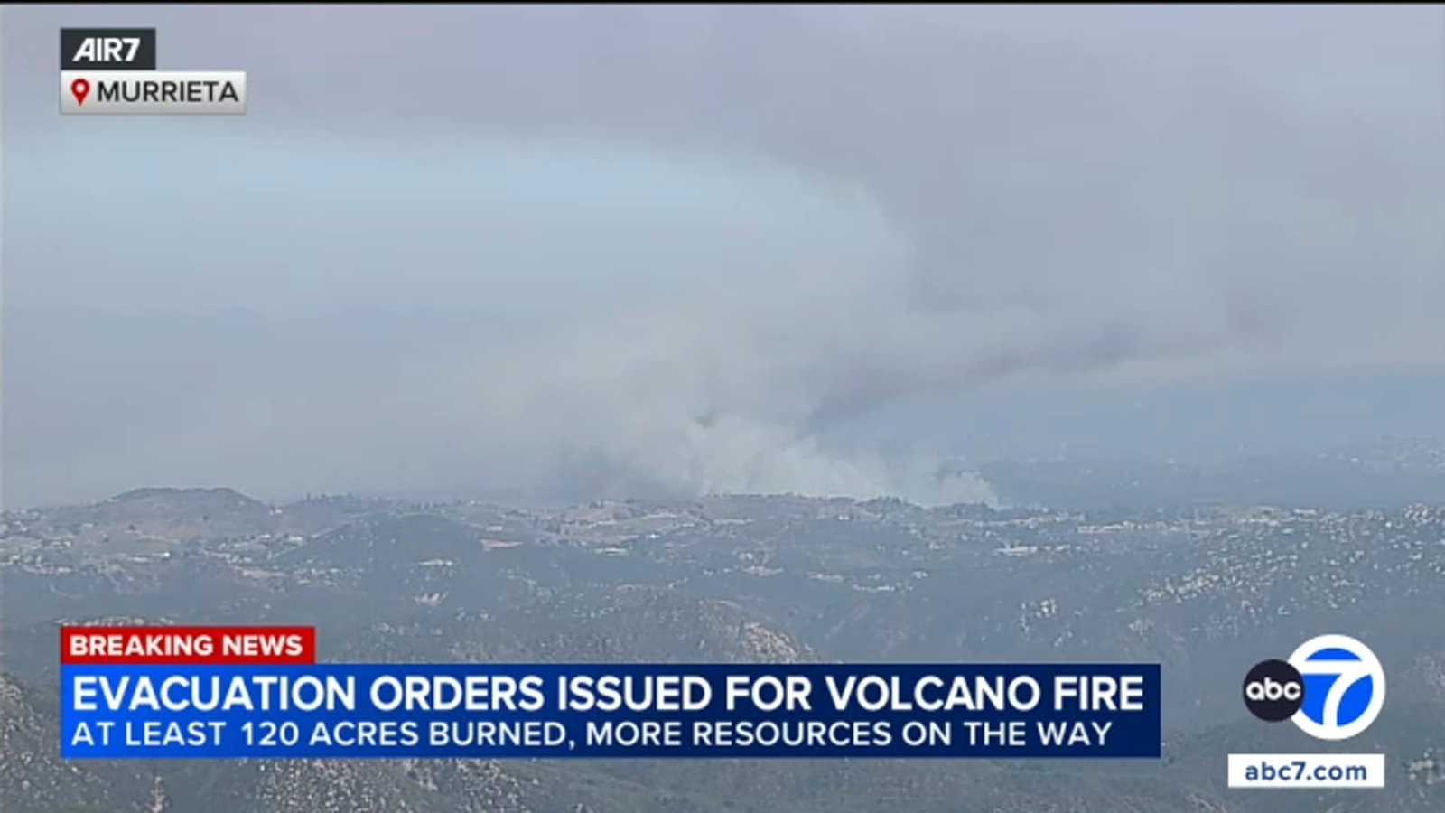
The Volcano Fire, a brush blaze reported at 2:50 p.m. on Tuesday, July 7, 2026, near Via Volcano and Tenaja roads west of Murrieta, California, prompted mandatory evacuation orders across eight Riverside County zones as Cal Fire reported the fire had grown to roughly 125 acres with no confirmed containment. For homeowners and investors with property in the De Luz hills, the fast-moving Volcano Fire is both a safety emergency and a stark reminder that wildfire risk can threaten equity overnight.
Key Takeaways
- The Volcano Fire erupted Tuesday afternoon near the Santa Rosa Plateau Ecological Preserve and spread through medium to heavy brush at a moderate rate.
- Mandatory evacuation orders cover eight Riverside County zones, with seven additional zones under evacuation warnings as of late Tuesday.
- Cal Fire assigned multiple air and ground crews, including three air tankers and two water-dropping helicopters, with no injuries reported.
- Tenaja Road west of Via Volcano was closed, and KESQ reported no evacuation relief centers had been announced as of 4 p.m.
- Property owners in high-risk corridors should verify evacuation zones, document assets, and review insurance before flames reach the doorstep.
What Is the Volcano Fire and Where Is It Burning?
The Volcano Fire is a brush fire that Cal Fire and Riverside County crews began battling on Tuesday, July 7, 2026, in the unincorporated De Luz community west of Murrieta. The blaze was reported at 2:50 p.m. in the area of Via Volcano and Tenaja roads, along the boundary of the Santa Rosa Plateau Ecological Preserve, according to the Riverside County Fire Department and ABC7 Los Angeles.
The Desert Sun reported the fire near Tenaja Road and Sierra Ellana at 75 acres shortly after 3:36 p.m., noting that no evacuations or road closures had been ordered at that early stage. Later updates from Cal Fire, cited by ABC7, put the burned area at 125 acres. KESQ reported the blaze had charred about 120 acres and threatened rural properties spread across large lots, many accessed by dirt roads.
Flames moved at a moderate rate through medium to heavy brush. Multiple engine and hand crews from Riverside County, Murrieta Fire and Rescue, the Riverside Fire Department, the Corona Fire Department, and Cal Fire San Diego County responded, according to KESQ. Three Cal Fire air tankers and two water-dropping helicopters began drops just after 3 p.m.
Which Areas Face Evacuation Orders and Warnings?
By late Tuesday, Cal Fire had issued mandatory evacuation orders for zones RVC-2244, RVC-2243, RVC-2197, RVC-2145, RVC-2146, RVC-2147, RVC-2245, and RVC-2198-B, ABC7 reported. Evacuation warnings, meaning residents should prepare to leave quickly, covered RVC-2077, RVC-2076, RVC-2143-A, RVC-2292, RVC-2246, RVC-2198-A, and RVC-2144.
KESQ reported that at 3:45 p.m., evacuation orders applied to properties along Tenaja Road between Avenida Caleta to the west and Clinton Keith Road to the east. Riverside County sheriff's deputies shut down Tenaja Road west of Via Volcano for public safety, according to ABC7 and KESQ.
No injuries had been reported as of Tuesday afternoon, KESQ said. The cause of the fire had not been determined. Cal Fire had not published a containment percentage in the updates cited by ABC7, underscoring that the incident remained active and fluid.
Where Can Evacuees Go and What Roads Are Closed?
KESQ reported that as of 4 p.m. Tuesday, no evacuation relief centers had been formally announced, reflecting how quickly conditions shifted in the first hours of the Volcano Fire. Anyone ordered to leave should monitor official Riverside County and Cal Fire channels for the latest shelter confirmations before heading out.
The primary confirmed road closure was Tenaja Road west of Via Volcano. Beyond that closure, the Desert Sun's earliest update at 3:36 p.m. listed no additional road shutdowns, though conditions evolved as evacuation orders expanded later in the afternoon.
For investors tracking rental portfolios or second homes in southwest Riverside County, road closures and sudden evacuation zones can delay tenant access and interrupt showing schedules during peak summer leasing season. Even a mid-size blaze can disrupt cash flow when properties sit inside an active fire perimeter.
Why Does the Volcano Fire Matter for Property Owners and Investors?
Wildfires in the hills west of Murrieta are not abstract headlines for the families and landlords who hold acreage along Tenaja Road and the Santa Rosa Plateau corridor. KESQ described residences on lots that can span several acres, often reached by unpaved roads. That rural layout raises both property values and operational risk: access delays complicate evacuations, and brush-choked hillsides can accelerate spread before crews establish containment lines.
For anyone treating California real estate as a wealth-building asset, the Volcano Fire illustrates why fire-season preparedness belongs alongside mortgage math and cap-rate analysis. Documenting structures, maintaining defensible space, and confirming that homeowners or landlord insurance policies cover wildfire damage can mean the difference between a recoverable setback and a total loss of equity. Our Wealth Hacks and Passive Income coverage regularly examines how external shocks, from rate hikes to natural disasters, reshape returns on property-heavy portfolios.
Tuesday's Volcano Fire followed a familiar afternoon pattern seen across inland Southern California: ignition in rugged terrain, rapid acreage growth, and zone-based evacuations before containment figures stabilize. The Desert Sun, KESQ, and ABC7 all described the incident as a developing story, meaning acreage totals and evacuation boundaries could change as crews work overnight.
How Should Residents and Landlords Respond Right Now?
If you are in an ordered evacuation zone, leave immediately with essential documents, medications, and proof of insurance. Do not wait for visible flames; ember cast and shifting winds can close escape routes within minutes in canyon terrain. Monitor Cal Fire and Riverside County sheriff advisories for zone changes rather than relying on unverified social media posts.
Landlords with tenants in warning zones should share official evacuation maps, confirm contact numbers, and clarify whether lease agreements address temporary displacement. Remote property owners monitoring the Volcano Fire from out of state should avoid driving toward the fire line and instead track updates from KESQ and other official outlets for re-entry timelines.
This is a developing story. Acreage totals, containment percentages, and evacuation boundaries may change as crews work through Tuesday night and into Wednesday. The primary financial lesson is unchanged: in Southern California's inland empire, wildfire exposure is a line item every property owner must budget for, whether early reports placed the Volcano Fire at 75 acres or later updates reached 125.