Tornado warning San Francisco: Twin waterspouts over Bay
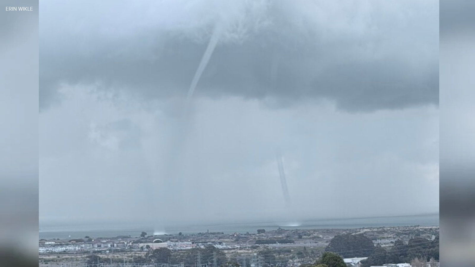
A tornado warning San Francisco Bay Area residents monitored Monday afternoon coincided with twin waterspouts over San Francisco Bay near Candlestick Point, as the National Weather Service also alerted Santa Cruz County. No damage was reported from the waterspouts, a sight ABC7 noted had not been recorded over the bay in 28 years.
Key Takeaways
- Twin waterspouts formed south of the Bay Bridge near Candlestick Point and Brisbane on Monday, with video shared widely online.
- The National Weather Service issued a special marine warning shortly after noon and tornado warnings for Boulder Creek and Davenport in Santa Cruz County.
- No damage or confirmed tornado touchdowns were reported from Monday’s alerts.
- A multi-day Level 2 storm series is expected to bring heavy rain, flooding risks, and up to 4 feet of Sierra snow later this week.
Dramatic unsettled weather around the Bay Area pushed the National Weather Service to warn about tornadoes and waterspouts Monday afternoon, according to ABC7 Bay Area.
Images and video showed a pair of waterspouts forming south of the Bay Bridge near Candlestick Point and Brisbane. The Weather Service issued a special marine warning a little after noon. Those alerts cover coastal waterways expected to produce winds of 34 knots or more and are also issued for waterspouts.
More BlasterPost coverage for staying resilient through disruptive weeks lives in the Longevity & Biohacking category hub.
What happened with the tornado warning San Francisco area?
At 1 p.m., the Weather Service issued two tornado warnings for Santa Cruz County—one for the Boulder Creek area and one for Davenport. As of about 2 p.m., no tornadoes had been reported forming in those areas, and the warnings were later canceled.
Weather Service meteorologist Rachel Kennedy said people should watch for similar alerts through the week as early-season storms move through Northern California. “It looks like a very convectively active week,” Kennedy said. She urged residents to enable emergency alerts on phones and check Weather Service social media.
Why were the San Francisco Bay waterspouts so rare?
ABC7 reported that NOAA’s storm events database shows no recorded waterspouts over San Francisco Bay in the last 28 years. Onlookers still captured the scene, including twin waterspouts near Candlestick Point featured by The Weather Channel.
KRON4 aired video filmed by Jordan Perkins-Lewis from Visitacion Valley, who said the waterspout was near Candlestick Park. The National Weather Service compares waterspouts to tornadoes over water, including tornadic types that form over water or move from land to water, and generally less dangerous fair-weather waterspouts.
NWS guidance says the best way to avoid a waterspout is to move at a 90-degree angle to its apparent path and never stand close to it. Monday’s waterspout caused no damage.
What severe weather is still ahead this week?
ABC7 meteorologist Drew Tuma rated the incoming pattern a strong Level 2 storm on the station’s Storm Impact Scale, with a chance it could rise to Level 3. The next system was expected Tuesday night through early Friday, with the greatest impacts Wednesday and Thursday, and rain possibly lingering into the weekend.
Moderate to heavy rain could bring minor flooding. Burn-scar areas face higher flash-flood, mud, and debris-flow risk. A powerful winter storm may dump up to 4 feet of snow in parts of the Sierra Nevada, with mountain travel potentially nearly impossible Wednesday and Thursday.
Along the coast Monday, massive waves flooded and piled sand on roads near Pacifica Pier, while Rockaway Beach surf narrowly missed cars in a nearby parking lot. Forecasters say similar convective activity may continue, so Bay Area residents should keep alerts on as the week unfolds.