Radar tracks Saturday flood risks in Northeast Florida
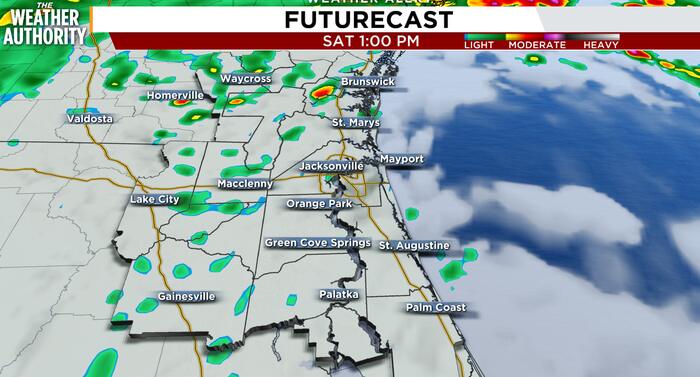
Live radar shows Saturday flooding risks continuing along tidal areas in Northeast Florida, while rain is expected to taper off this afternoon as heavier showers shift into Southeast Georgia. A Flood Watch remains active, with the greatest threat near high tide from downtown Jacksonville southward and along the Intracoastal Waterway. Coastal and river levels stay elevated, so minor to moderate tidal flooding is likely and localized major flooding remains possible in Putnam and Flagler counties, according to News4JAX.
Key Takeaways
- Flood Watch conditions continue across parts of Northeast Florida, with peak impacts near high tide.
- Rain chances drop today as heavier showers move into Southeast Georgia, though local totals of 1–2 inches are still possible.
- A Coastal Flood Warning covers the St. Johns River from downtown Jacksonville southward as water levels stay high.
- Very high rip current risk, high surf, and marine advisories make beach and boating conditions unsafe.
Where does live radar show the worst flooding risk today?
The greatest flooding risk is focused along tidal areas near high tide, especially from downtown Jacksonville southward. News4JAX meteorologist Michelle McCormick reported that tidal surge and runoff will keep coastal and river levels elevated.
Expect minor to moderate tidal flooding along the Northeast Florida coast and the Intracoastal Waterway. Moderate flooding is most likely from downtown Jacksonville southward, with localized major flooding possible in parts of Putnam and Flagler counties. Impacts can persist for several days as repeated high-tide cycles push water into low-lying neighborhoods and marinas.
Will the rain taper off this afternoon as forecast?
Yes. Overall rain chances drop over Northeast Florida today as the main heavier rain shifts north into Southeast Georgia. Additional rainfall of about 1–2 inches is still possible locally, while Southeast Georgia could see 1.5–2.5 inches in places.
Elsewhere in Florida, conditions have varied widely. The Tampa Bay Times reported that Tampa Bay was spared the worst of a statewide rain event that dumped as much as 17 inches in two days in some areas. In the Big Bend, WCTV said showers would linger into Saturday before improvement later in the weekend.
Skies should stay mostly cloudy with scattered showers at times. Northeast Florida temperatures could reach the lower 70s, while inland Southeast Georgia may remain overcast and cooler in the 60s.
What travel, beach, and marine hazards should residents watch?
Commuters should allow extra time and watch for standing water near low-lying underpasses and I-95 exit ramps. Riverside roads and low bridges along the St. Johns River may also be affected while levels remain elevated.
A Wind Advisory for coastal areas was ending Saturday morning, but marine hazards continue. A High Surf Advisory and very high rip current risk remain at local beaches into tonight. A Gale Warning for Atlantic waters runs through Saturday morning, followed by a Small Craft Advisory into tonight.
Beachgoers should avoid swimming, and boaters may want to delay plans. Overnight, winds should turn light from the south or southwest, with low stratus and areas of fog possible, especially inland Southeast Georgia. Lows look to settle in the upper 50s to 60s inland and the lower 60s near the coast.
For more weather and tech explainers, browse Future Tech & AI Wonders on BlasterPost.