Polo storm moisture will trigger Southwest flooding
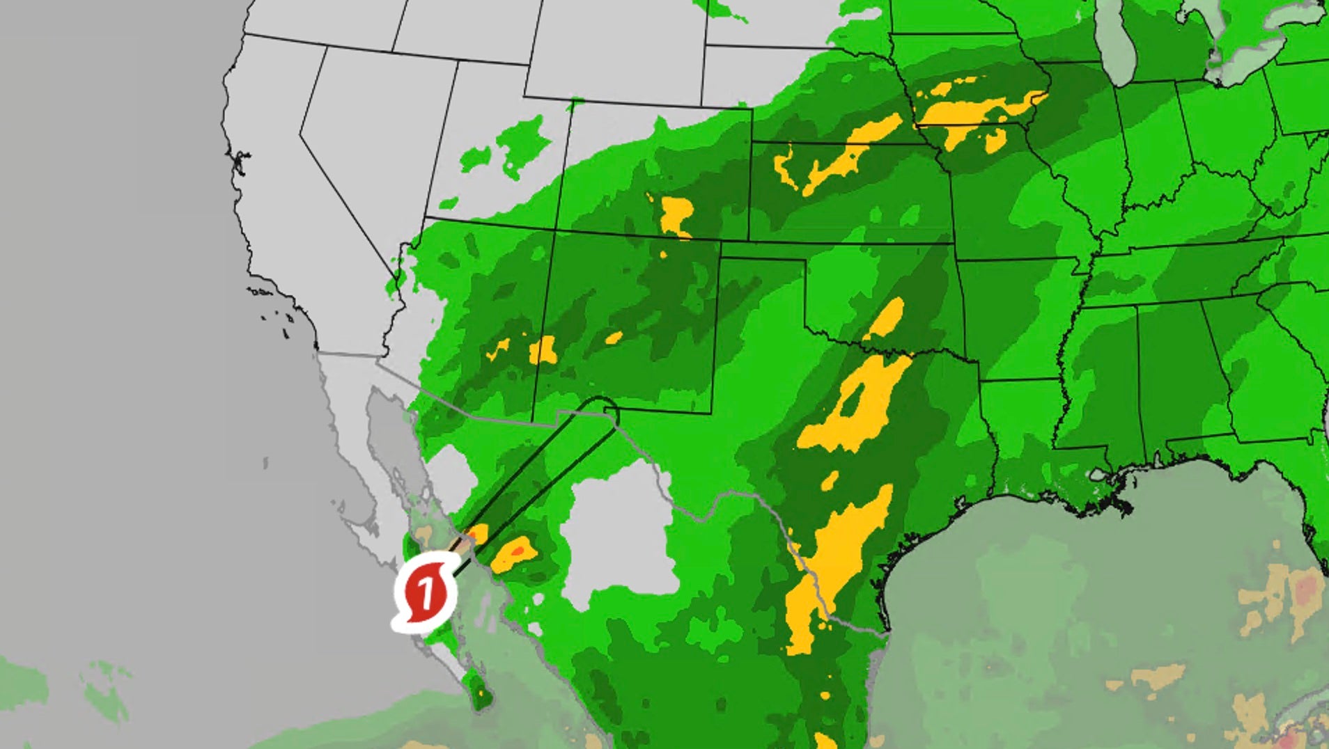
Hurricane Polo’s tropical moisture — the polo storm plume now surging north — is already triggering flash flooding across the U.S. Southwest and will spread into Texas, Oklahoma and the Midwest over the next few days, with rainfall rates of 1–3 inches per hour and life-threatening runoff possible through Thursday.
The Category 2 hurricane made landfall Tuesday just south of Las Barrancas in Baja California Sur with 110 mph winds, then moved inland into Sonora. Its historic moisture plus a plunging jet stream is lofting near-record late-September humidity over Arizona, New Mexico and far west Texas, according to The Weather Channel.
Key Takeaways
- Polo struck Baja California Sur as a Category 2; about 700 people remained in shelters Tuesday, with no deaths immediately reported.
- Southwest spots may see 2–4 more inches; Southern Plains 3–5 inches; a stripe of 3+ inches is forecast from Kansas toward Illinois.
- Greatest early risk covers Arizona, New Mexico, Colorado, Kansas and the Texas and Oklahoma panhandles.
- More than 150 million people across up to 30 states face a weeklong flood threat as Polo moisture and Tropical Storm Rachel feed storms.
- Officials urge “Turn around. Don’t drown” — never drive flooded roads or enter arroyos and washes.
Where has the polo storm already caused flooding?
Bands of rain swept the Southwest on Tuesday, sending dry arroyos into flood. North of Phoenix, a box truck was swept away in a wash; the driver escaped safely, and at least one other water rescue occurred in the metro area. Flooding hit washes and Interstate 10 between Tucson and Phoenix, plus roads in New Mexico.
Earlier impacts included flooding in Laughlin, Nevada; stranded vehicles in Bullhead City, Arizona, and Needles, California; and a cargo container swept down Utah’s East Fork of the Virgin River near Zion. In Orderville, Utah, floodwater surrounded a home. In Puerto San Carlos, Mexico, residents waded past downed trees after Polo passed, Associated Press reporting via Anchorage Daily News said.
How much rain could fall across the Southwest and Plains?
Polo produced as much as a foot of rain in northwestern mainland Mexico. In the U.S., The Weather Channel expects up to 2 to 4 additional inches across the Southwest, with rates of 1 to 3 inches per hour — enough that some communities could see more than a month’s rain from this event alone.
From Texas into Oklahoma, including Dallas, Austin and San Antonio, 3 to 5 inches are possible. A stripe of 3 inches or more is expected from Kansas toward Nebraska, Missouri, Iowa and northern Illinois. FOX Weather notes many areas could receive 6 to 8 inches or more, and Tuesday’s Level 3 flash flood risk covered more than 230,000 square miles.
North-central New Mexico, including Albuquerque and Santa Fe, could see 3 to 4 inches through Wednesday. Saturated September soils mean runoff starts faster, NWS meteorologist Carter Greulich in Albuquerque warned.
When will the flood threat reach Texas and the Midwest?
Through early Wednesday, southeast Arizona — including Tucson — and much of New Mexico face particular risk as Polo’s core meets another system over the Four Corners. Nearly a dozen states are at flash-flood risk, with tropical moisture extending as far north as Minnesota.
Wednesday shifts the threat into Texas, Oklahoma and Colorado, with higher risk near Oklahoma City and Omaha, and moisture reaching Wisconsin and Michigan. Thursday extends risk from Texas to Michigan, with Dallas and the Hill Country again in the heaviest swath. By Friday, rain begins shifting east, though Oklahoma and Texas may see a final heavy pulse.
FOX Weather also flags a Level 2 of 5 severe-storm risk Wednesday near Abilene and Wichita Falls, Texas, including embedded tornadoes. For more forecasting coverage, visit BlasterPost’s Future Tech & AI Wonders hub. Take flash flood warnings seriously, avoid night travel in watch areas, and move to higher ground if a flash flood emergency is issued.