No tsunami threat after 4.6 earthquake off Kona Coast
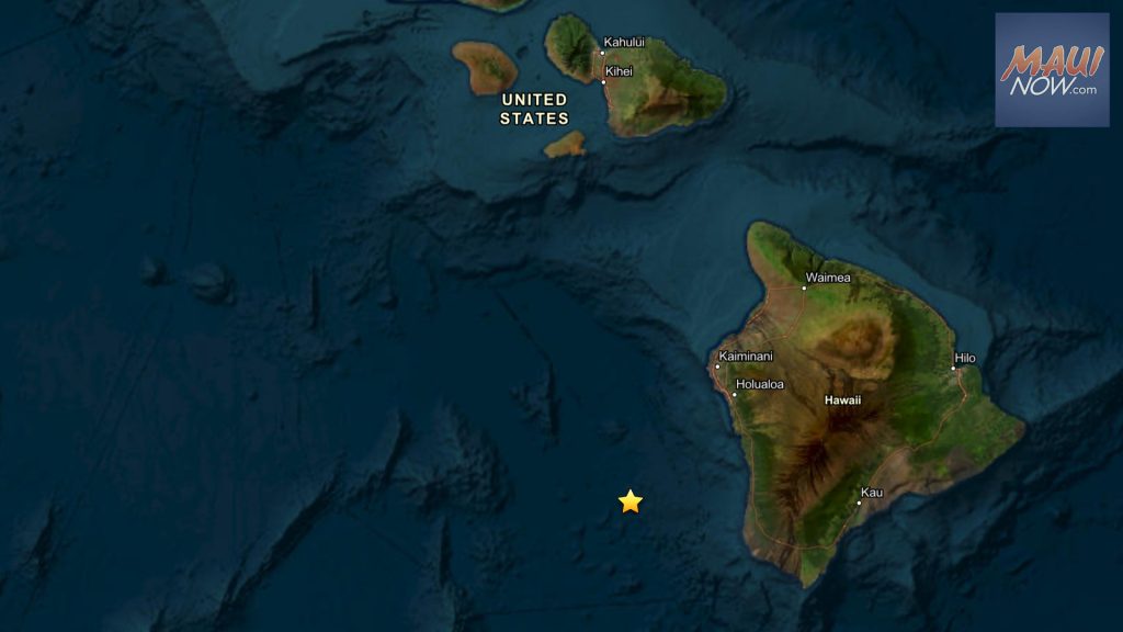
Hawaiʻi faces no tsunami threat after a preliminary magnitude 4.6 earthquake struck the deep ocean off the Kona Coast of Hawaiʻi Island at 8:17 p.m. HST on Thursday, July 9, 2026. The Pacific Tsunami Warning Center says no tsunami is expected from this earthquake off Kona, though some areas may have felt shaking.
The U.S. Geological Survey reported the event at 19.238°N, 156.358°W, at a depth of 7 kilometers. It was located about 36.2 miles southwest of Kailua-Kona and 33.5 miles west-southwest of Captain Cook, according to reporting from Maui Now. USGS event details are listed under earthquake event page hv75000056.
Key Takeaways
- A magnitude 4.6 earthquake off the Kona Coast occurred at 8:17 p.m. HST on July 9, 2026.
- The Pacific Tsunami Warning Center reported no tsunami threat to Hawaiʻi.
- The quake was centered in deep ocean water at a depth of 7 km.
- Offshore Hawaiian earthquakes are often tied to lithospheric flexure, per the USGS.
- Residents across Hawaiʻi should review official alerts after significant seismic activity.
What happened during the earthquake off Kona?
On the evening of July 9, 2026, Hawaiʻi Island residents and visitors may have noticed shaking from a preliminary magnitude 4.6 temblor. Maui Now reports the earthquake occurred in the deep ocean west of the Kona Coast, not on land.
USGS positioning placed the epicenter 89.1 miles west-southwest of Hilo and 172.1 miles southeast of Honolulu. Because the event unfolded offshore in the evening, many people turned first to tsunami advisories rather than structural damage reports.
Is there a tsunami threat to Hawaiʻi?
No. The Pacific Tsunami Warning Center explicitly stated that no tsunami is expected following this earthquake. That answer matters most for coastal communities from Kona to Oʻahu, where even moderate offshore quakes routinely prompt public checks on ocean hazards.
Maui Now notes that while no tsunami threat exists, some areas may have experienced shaking. That distinction—felt shaking without a tsunami—is common for moderate events centered at sea.
Why do earthquakes happen off Hawaii's coast?
The U.S. Geological Survey explains that not all Hawaiian earthquakes come from moving magma. Over millions of years, the weight of the island chain bends the brittle lithosphere downward, sometimes releasing strain as earthquakes called flexure events.
These events often occur in coastal or offshore regions and can be felt across a wider area because seismic waves travel efficiently through dense lithosphere. The USGS also notes that not every deep offshore quake is a flexure event; seismic swarms such as the Pāhala area activity involve different processes.
A companion USGS graphic on lithospheric flexure illustrates how volcanic load on the Pacific Plate can generate widely felt deep earthquakes across the state.
What should residents watch for after this quake?
For this July 9 event, official guidance centers on the confirmed absence of tsunami risk and the possibility of local shaking. Anyone seeking technical data can consult the USGS Hawaiian Volcano Observatory earthquake listings linked from Maui Now's initial report.
For broader coverage of how science and public alerting intersect, see our Future Tech & AI Wonders section. Hawaiʻi residents should continue to rely on the Pacific Tsunami Warning Center and USGS for verified updates after significant offshore seismic activity.