Hurricane tracker: Active Pacific, quiet Atlantic in 2026
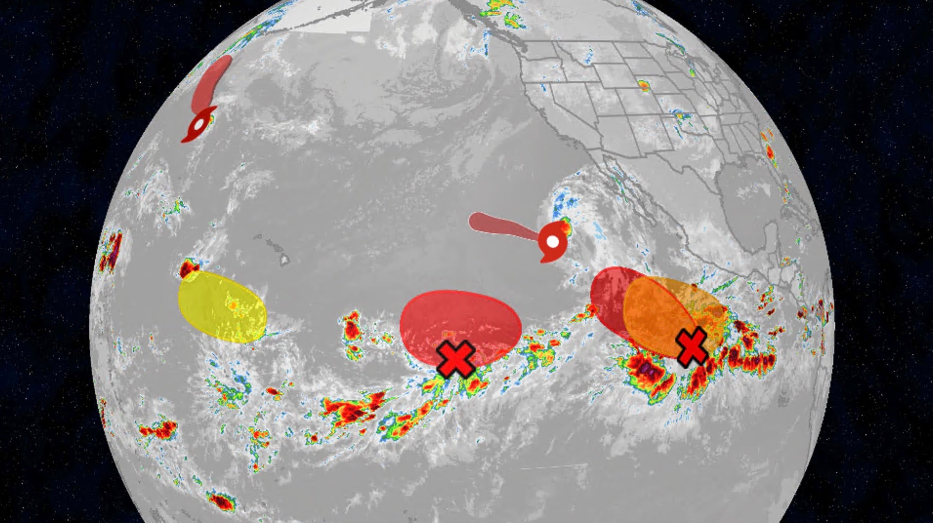
The latest hurricane tracker shows an active Pacific and a quiet Atlantic this week. Tropical Storms Iselle and Lala are weakening far from land, while Julio’s remnants fade. None of the named systems threaten coastlines right now, as strong El Niño fuels Pacific activity and keeps the Atlantic subdued. Map-based trackers from The Weather Channel and the National Hurricane Center remain the fastest way to follow cones, waves, and sea-surface heat.
Key Takeaways
- Pacific basins are hosting Tropical Storms Iselle and Lala, plus multiple waves under watch.
- Julio has weakened to remnants west of Baja California and is expected to merge into Iselle’s circulation.
- No named storm currently poses a land threat; no tropical watches or warnings are in effect for land areas.
- Strong El Niño is boosting East/Central Pacific activity while the Atlantic stays below average.
- Hawaii is forecast mostly sunny and breezy, with no significant storm impacts expected this week.
What does the latest hurricane tracker show right now?
As of Aug. 26, 2026, The Weather Channel’s hurricane season maps tracker highlights Iselle and Lala alongside other Pacific areas to watch. Satellite and cone graphics cover forecast tracks, sea-surface temperatures, and Atlantic inhibitors such as wind shear and Saharan dust.
According to the Honolulu Star-Advertiser citing the National Hurricane Center, Iselle was centered about 815 miles west of the southern tip of Baja California at 5 p.m. Aug. 25, with 50 mph maximum sustained winds and a west-northwest motion near 9 mph. Forecasters said further weakening is likely, with a possible post-tropical transition Thursday and dissipation by Friday far from Hawaii.
Lala was about 540 miles north of Pearl and Hermes Atoll in the Northwestern Hawaiian Islands with 50 mph winds, still far northwest of the main islands and weakening. The storm spent a week as a tropical cyclone after becoming a tropical storm on Aug. 13, brushing South Point as a Category 1 hurricane on Aug. 15, then passing south of the smaller islands as a strong tropical storm on Aug. 16.
Julio’s remnants were reported dissipating roughly 630 miles west of Baja’s southern tip, moving north near 25 mph and forecast to drift into Iselle’s circulation. WPEC reported the Pacific also had four tropical waves under monitoring alongside the named systems.
Why is the Pacific so busy while the Atlantic stays quiet?
WPEC notes the Pacific has already produced 12 named storms this year, three of them hurricanes, while the Atlantic remains unusually quiet—typical under a strong El Niño. Weaker eastern Pacific trade winds lower wind shear, and warmer ocean temperatures add fuel, so storms develop more readily there.
The Weather Channel’s Atlantic maps flag the flip side: strong wind shear (shown in purple) and dry, dusty Saharan air (brown shading) that can choke thunderstorms needed for tropical growth. Meteorologists also track Accumulated Cyclone Energy (ACE) to compare how much total storm energy a season has produced versus average.
For more explainers on map tools and seasonal models, browse BlasterPost’s Future Tech & AI Wonders hub.
Do any of these storms threaten Hawaii or the U.S. mainland?
No. WPEC and the Star-Advertiser both report that none of the named Pacific storms pose a threat to land, and no tropical-related watches or warnings are in effect for land areas. Disturbances being watched have formation odds ranging from about 20% to 90% over the next week, but none are forecast to bring significant impacts to Hawaii.
Locally, Hawaii is expected to stay mostly sunny and breezy, with daytime highs in the upper 80s to low 90s and trade winds of 15–25 mph. Aside from a limited small-craft advisory for selected channels and Big Island waters, officials urge residents to stay prepared even during a below-average Atlantic outlook—because quiet seasons can still produce dangerous storms.