Flash flooding threat hits Central Texas as storms arrive
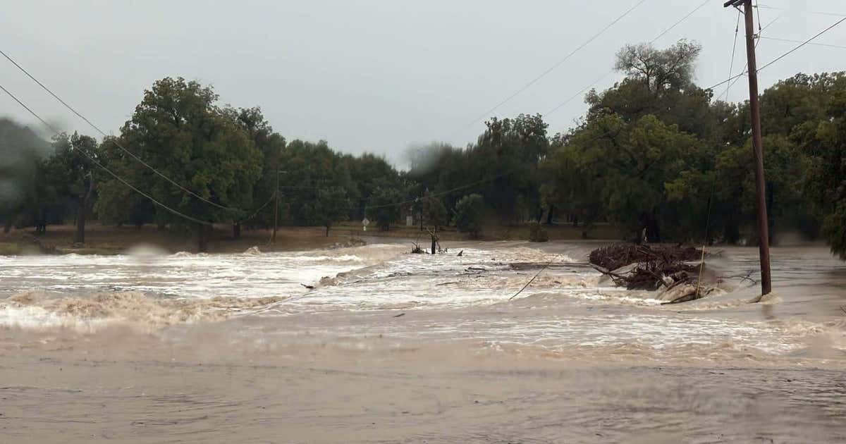
Central Texas faces a rising flash flooding threat as heavy storms and tropical moisture push through Austin and San Antonio on Thursday, Oct. 1, 2026. The National Weather Service has a Flood Watch in effect through Friday evening, while forecasters warn of life-threatening inundation near low-water crossings and flood-prone roads.
Key Takeaways
- A Flood Watch covers much of South and Central Texas from 7 p.m. Wednesday through 7 p.m. Friday.
- The Weather Prediction Center rates most of the region a level 3 of 4 “Moderate” flood threat through tonight.
- An additional 2–4 inches of rain is expected across much of Central Texas, especially along the I-35 corridor and east.
- San Antonio lists at least 21 flooded road closures; Austin-area reports include a flood advisory, road closures, and an airport ground stop.
Why does flash flooding matter across Central Texas today?
Storms loaded with tropical moisture are moving through Central Texas, and local outlets say the setup can turn dangerous quickly. According to MySA, the National Weather Service issued a Flood Watch for much of South and Central Texas lasting until 7 p.m. Friday. A cold front paired with tropical moisture is expected to deliver periods of heavy rainfall that could produce life-threatening flash flooding.
In Austin, FOX 7 Austin is tracking alerts, warnings, and watches as heavy rain and possible flooding continue. The station’s live coverage also notes a ground stop at Austin-Bergstrom International Airport, a new flood advisory for parts of Central Texas, a South Austin road closure, and high-water road closures in Kerrville.
How bad is the flash flooding risk right now?
KXAN reports steady rain already moving through Central Texas after several inches fell in the Hill Country earlier Thursday. Heavy rain and thunderstorms were likely through the afternoon, with rain chances winding down later in the evening before more rounds return overnight and Friday.
The Weather Prediction Center has issued a level 3 out of 4 “Moderate” flood threat for most of the region through tonight. Forecasters expect an additional 2–4 inches of rain for much of Central Texas, especially along the I-35 corridor and areas farther east. In any Flash Flood Warning, local meteorologists repeat the standard safety message: turn around, don’t drown.
Where are roads closed and how should drivers respond?
Flooding has already disrupted travel in the San Antonio area. MySA says the Bexar Flood map showed 21 road closures in real time as severe storms moved in on Oct. 1. Bexar County Public Works crews deployed and pre-positioned barricades at known low-water crossings and other flood-prone spots, while additional staff stood by if more help was needed.
County crews planned to monitor creeks, drainage ways, and low-water crossings to keep debris from damming floodwater. The Bexar County Office of Emergency Management urged residents to stay weather-aware, understand flood risk around their homes, secure loose outdoor items, and clear debris that could pool water.
Drivers heading through Austin and surrounding counties should treat flooded pavement as impassable, avoid low-water crossings, and expect sudden closures as storms train over the same corridors. For more BlasterPost coverage of innovation and emergency-response tech, see our Future Tech & AI Wonders hub.
Will the rain continue into the weekend?
KXAN says overnight temperatures cool into the 60s and 70s with scattered tropical downpours, and rain chances continue Friday with scattered to numerous rounds of storms. Weekend highs are forecast cooler than normal in the 70s and 80s, with scattered rain chances Saturday and Sunday before drier conditions return early next week.
Officials and meteorologists agree on the near-term priority: respect barricades, skip flooded roads, and keep checking local alerts while the Flood Watch and moderate flood threat remain in effect across Central Texas.