Canadian wildfires send smoke across US, threatening air quality
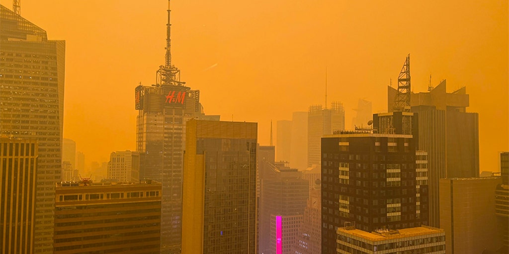
Canadian wildfires across western Ontario and northern Minnesota are sending thick smoke toward the Great Lakes and Northeast through Thursday, and the FOX Forecast Center warns air quality could turn very unhealthy for millions along the I-95 corridor by Wednesday evening. A major wind shift over the next 24 to 36 hours is expected to pour heavy smoke into the Lower 48, creating milky skies and health risks from Minnesota to Boston, New York City, and Philadelphia.
If you earn income from rental properties, outdoor businesses, or remote work tied to northern states, this is not just a weather headline. Poor air quality forces people indoors, disrupts travel, and raises health costs that can hit your bottom line faster than a routine forecast update.
Key Takeaways
- Wildfires across western Ontario and northern Minnesota are sending smoke toward the Great Lakes and Northeast through Thursday.
- Northeastern Minnesota faces air quality alerts, with the thickest smoke plumes likely producing very unhealthy conditions near the ground.
- Smoke is forecast to reach Boston, New York City, and Philadelphia by Wednesday evening, with severity potentially comparable to the June 2023 event.
- An extreme heat warning and heat dome across Minnesota and the Northern Plains are intensifying fire risk and compounded health threats.
- Residents and business owners should monitor official alerts, limit outdoor exposure, and plan for productivity and revenue disruptions.
Why Are Canadian Wildfires Sending Smoke Into the US Again?
A recent wildfire outbreak across western Ontario, Canada, and Minnesota is driving the new smoke invasion. According to FOX Weather, several fires sparked and intensified in northern Minnesota on Monday as a heat dome continues to drive record temperatures across the Northern Plains.
Minnesota's Pollution Control Agency has issued air quality alerts for parts of northeastern Minnesota, including Two Harbors, Hibbing, Ely, and the Grand Portage Tribal Nation. The FOX Forecast Center says a major shift in wind direction over the next 24 to 36 hours will allow heavy concentrations of wildfire smoke to pour into the Lower 48.
Under the thickest bands of the plume, reduced visibility is possible, and air quality will likely become very unhealthy if the latest computer forecast models are correct. The outbreak is sending thick plumes toward the Great Lakes and Northeast through Thursday, bringing extremely hazardous air quality and potentially orange skies reminiscent of the Mars-like haze that enveloped New York City in June 2023.
Which US Regions Will See the Worst Air Quality?
The impacts unfold in stages. Milky, hazy skies are expected across the Upper Midwest and Great Lakes beginning Wednesday morning. The biggest declines in air quality are forecast where the thickest smoke concentrates near the ground.
By Wednesday, the smoke plume is expected to move toward the Interstate 95 corridor in the Northeast, reaching cities such as Boston, New York City, and Philadelphia by Wednesday evening. Air quality issues will be compounded as the heat dome intensifies over the Northeast, bringing near-record temperatures for the region.
In Minnesota, wildfire smoke could become more noticeable across parts of central and northern Minnesota on Wednesday as winds shift, according to FOX 9 Minneapolis-St. Paul. That timing matches the FOX Forecast Center's outlook for heavy smoke pouring into the Lower 48 as wind patterns change over the next 24 to 36 hours.
How Does Minnesota's Heat Wave Make the Smoke Crisis Worse?
Smoke alone is dangerous. Combined with extreme heat, it becomes a dual threat to health and household budgets. The Star Tribune reports that an Extreme Heat Warning for feels-like conditions at or near 100 degrees covers an area from Mankato north to the Canadian border and remains in effect until 9 p.m. Thursday.
Actual temperatures Monday flirted with 100 degrees across northern Minnesota, including International Falls, where a triple-digit reading last happened in 1923. High temperatures are expected to top 90 degrees through Saturday, with the heat wave rolling into its third day and no relief in sight.
FOX 9 reports the Twin Cities metro daytime high is around 95 degrees Tuesday, with heat index values near 98. An extreme heat warning remains in effect for much of Minnesota, with widespread highs in the 90s continuing through much of the week before cooling slightly heading into next week. Hot, humid afternoons and warm overnight lows in the upper 60s and low to mid-70s leave little recovery time for residents without air conditioning.
What Should You Do to Protect Your Health and Finances?
When air quality drops under thick smoke bands, limit outdoor exertion and stay indoors when possible. Under the thickest plume concentrations, reduced visibility is possible and air quality will likely become very unhealthy. Track local air quality readings rather than judging risk by sky color alone.
From a wealth and passive-income perspective, prolonged poor air quality affects more than lungs. Outdoor service businesses lose customers, construction and landscaping crews face shutdowns, and employees calling in sick can stall projects tied to rental turnovers or seasonal side hustles. If you manage properties in affected states, communicate early with tenants about indoor air filters, HVAC maintenance, and flexible work arrangements.
For broader financial resilience during climate-driven disruptions, explore strategies in our Wealth Hacks & Passive Income section. Keep windows closed during peak smoke hours, use N95 masks if you must be outdoors, and build contingency plans for income streams that depend on clear skies and healthy air.
Could This Smoke Event Match the Infamous 2023 New York City Haze?
The overall severity of the current smoke event remains unclear. However, the FOX Forecast Center notes early indications that, if computer forecast models prove accurate, the concentration of smoke could be comparable to the infamous June 2023 event that enveloped New York City in Mars-like orange skies.
That 2023 episode became a wake-up call for millions who assumed wildfire smoke was a West Coast problem. This week's forecast suggests the Great Lakes and Northeast may again face extremely hazardous air quality, potentially with similarly dramatic haze and milky skies across the Upper Midwest and Great Lakes.
Heat gradually eases heading into the weekend in Minnesota, with FOX 9 forecasting temperatures falling into the low 90s Friday and Saturday before moving closer to seasonal averages next week. Smoke impacts, however, may linger independently of temperature drops, so continue monitoring alerts through Thursday and beyond.
What's the Bottom Line for US Residents This Week?
Canadian wildfires are not a distant crisis. They are an immediate air-quality and economic stress test for millions of Americans, from northeastern Minnesota to the I-95 corridor. The combination of fire smoke and a persistent heat dome creates conditions that demand attention now, not after skies turn orange.
Stay informed through official forecasts from FOX Weather and local outlets. Limit outdoor exposure when air quality deteriorates, and treat this event as both a public health emergency and a reminder that climate-linked disruptions can ripple through work, travel, and passive-income plans without warning.